
Ben R. Hodges
University of Texas at Austin
Geospatial representation of river channels
ABSTRACT: A geographic information system (GIS) approach for creating a three-dimensional (3D) topographic data set for straight or meandering river channels is presented. As input, the approach requires channel banklines, an initially arbitrary centerline, and a set of (x,y,z) river bathymetry points. A curvilinear orthogonal s,n-coordinate system that references data along and transverse to flow in the river channel is used. The methodology includes locating the channel centerline along the thalweg and then using it as a reference for assigning s,n-coordinates to the bathymetric data. The resulting bathymetric data in the s,n,z-coordinate system are used to create a square mesh, or FishNet, and this FishNet is then transformed back to the original x,y,z-coordinates to get a flow-oriented 3D mesh. The resulting 3D mesh is a network of lines transverse to the flow (cross sections) and lines parallel to the flow (profile lines). The output thus provides a flow-oriented 3D representation of channel geometry that can be used for river habitat and hydraulic modeling.
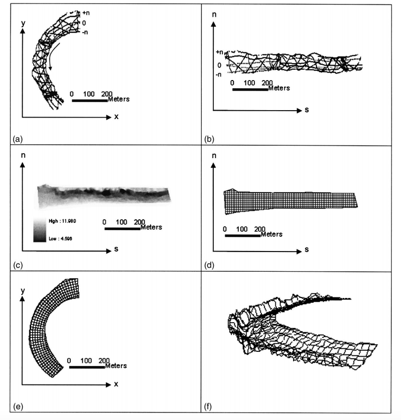
EXTRACT: Figure 8.

Fig. 8. Procedure for creating FishNet: (a) bathymetry points in (x,y,z); (b) bathymetry points in (s,n,z); (c) raster surface for bathymetry points in s,n,z-coordinates; (d) FishNet in s,n,z-coordinates; (e) FishNet transferred from s,n,z-coordinates to x,y,z-coordinates; (f) FishNet in three dimensions