
Ben R. Hodges
University of Texas at Austin
Geospatial Analysis
Publication Types:
On modeling subgrid-scale macro-structures in narrow twisted channels
.Journal ArticleEstuariesGeospatial AnalysisNumerical MethodsRivers
Li, Z., and B.R. Hodges (2020), "On modeling subgrid-scale macro-structures in narrow twisted channels," Advances in Water Resources, 135:103465. Jan. 2020. https://doi.org/10.1016/j.advwatres.2019.103465
Publication year: 2020
Building the Trinity River Delta Hydrodynamic Model
.ReportEstuariesGeospatial AnalysisNumerical Methods
Li, Z., B.R. Hodges, P. Passalacqua (2020), Building the Trinity River Delta Hydrodynamic Model, Technical Report, Center for Water and the Environment, University of Texas at Austin, Texas Data Repository Dataverse, V1, Jun. 2020, https://doi.org/10.18738/T8/BWOOPM
Publication year: 2020
A new form of the Saint-Venant equations for variable topography
.Journal ArticleGeospatial AnalysisNumerical MethodsPaper in reviewRiversStorm Water/Flooding
Yu, C.W., B.R. Hodges, and F. Liu (2020), “A new form of the Saint-Venant equations for variable topography," Hydrology and Earth System Sciences Discussion, accepted, Jun. 2020. https://doi.org/10.5194/hess-2020-75
Publication year: 2020
Modeling subgrid scale topographical effects on shallow marsh hydrodynamics and salinity transport
.Journal ArticleEstuariesGeospatial AnalysisNumerical Methods
Li, Z., and B.R. Hodges (2019), “Modeling subgrid scale topographical effects on shallow marsh hydrodynamics and salinity transport,” Advances in Water Resources, 129:1-15, May 2019. https://doi.org/10.1016/j.advwatres.2019.05.004
Publication year: 2019
Model instability and channel connectivity for 2D coastal marsh simulations
.Journal ArticleEstuariesGeospatial AnalysisNumerical Methods
Li, Z. and B.R. Hodges (2019), “Model instability and channel connectivity for 2D coastal marsh simulations,” Environmental Fluid Mechanics, 19:5:1309-1338, Nov. 2019. https://doi.org/10.1007/s10652-018-9623-7
Publication year: 2019
Modeling effects of subgrid scale topography in shallow coastal marshes
.ConferenceEstuariesGeospatial AnalysisNumerical Methods
Li, Z., and B.R. Hodges (2018), “Modeling effects of subgrid scale topography in shallow coastal marshes,” Gulf Estuarine Research Society Biennial Meeting, Galveston, Texas, USA, Nov. 8-9, 2018.
Publication year: 2018
Effects of bathymetric errors on salinity modeling in a shallow river delta
.ConferenceEstuariesGeospatial AnalysisNumerical Methods
Li, Z. and B.R. Hodges (2018), “Effects of bathymetric errors on salinity modeling in a shallow river delta,” E-proceedings of the 2nd International Symposium on Hydraulic Modelling and Measuring Technology Congress, Nanjing, China, May 30 – Jun. 1, 2018.
Publication year: 2018
Residence time-based classification of surface water systems
.Journal ArticleEstuariesGeospatial AnalysisHydrology
Jones, A.E., B.R. Hodges, J.W. McClelland, A.K. Hardison, and K.B. Moffett (2017), “Residence time-based classification of surface water systems,” Water Resources Research, 53:1-18, 2017. http://doi.org/10.1002/2016WR019928
Publication year: 2017
Effects of slope smoothing in river channel modeling
.ConferenceGeospatial AnalysisNumerical MethodsRivers
K. Kim, F. Liu, and B.R. Hodges, “Effects of slope smoothing in river channel modeling,” European Geophysical Union General Assembly 2017, Geophysical Research Abstracts, Vol. 19, EGU2017-9814, 2017. http://meetingorganizer.copernicus.org/EGU2017/EGU2017-9814.pdf
Publication year: 2017
Combining satellite photographs and raster lidar data for channel connectivity in tidal marshes
.ConferenceEstuariesGeospatial Analysis
Z. Li, and B. Hodges, “Combining satellite photographs and raster lidar data for channel connectivity in tidal marshes,” European Geophysical Union General Assembly 2017, Geophysical Research Abstracts, Vol. 19, EGU2017-9836, 2017. http://meetingorganizer.copernicus.org/EGU2017/EGU2017-9836.pdf
Publication year: 2017
Challenges in modeling the spatial variation in a shallow river delta
.ConferenceEstuariesGeospatial AnalysisNumerical Methods
B.R. Hodges and Z. Li, “Challenges in modeling the spatial variation in a shallow river delta,” 4th International Symposium on Shallow Flows, Eindhoven, Netherlands, June 26-28, 2017.
Publication year: 2017
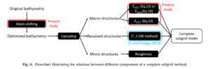
A subgrid approach for unresolved topography in shallow water hydrodynamic modeling
.Supervised ThesisEstuariesGeospatial AnalysisNumerical Methods
G. Shin, A subgrid approach for unresolved topography in shallow water hydrodynamic modeling, Ph.D. Dissertation, Department of Civil, Architectural, and Environmental Engineering, University of Texas at Austin, 203 pgs., Dec. 2016
Publication year: 2017
Real-Time Flood Inundation Mapping for Travis County, Texas
.ConferenceGeospatial AnalysisHazards/RisksHydrologyStorm Water/Flooding
X. Zheng, C.W. Yu, C. Fagan, H. Evans, D. Maidment, P. Passalacqua, B.R. Hodges; “Real-Time Flood Inundation Mapping for Travis County, Texas.” American Water Resources Association, 2016 Summer Specialty Conference, GIS and Water Resources IX, Sacramento, California, July 11-16, 2016. http://www.awra.org/meetings/Sacramento2016/doc/PP/Sess%2014%20abs.pdf
Publication year: 2016
Translating fine-scale topography into practical coarse-scale hydrodynamic models of braided rivers and deltas
.ConferenceEstuariesGeospatial AnalysisNumerical Methods
B.R. Hodges, and R. Li, “Translating fine-scale topography into practical coarse-scale hydrodynamic models of braided rivers and deltas” 36th International Association for Hydraulic Research World Congress (IAHR 2015), The Hague, Netherlands, June 28 – July 3, 2015.
Publication year: 2015
River geometry challenges for large-scale dynamic river modeling
.ConferenceGeospatial AnalysisHydrologyNumerical MethodsRivers
C.W. Yu, B.R. Hodges, and F. Liu, “River geometry challenges for large-scale dynamic river modeling,” American Geophysical Union Fall Meeting, San Francisco, Abstract H43A-1466, 14-18 December 2015. http://fallmeeting.agu.org/2015/scientific-program, https://agu.confex.com/agu/fm15/meetingapp.cgi/Paper/82425
Publication year: 2015
Representing hydrodynamically-important blocking features in coastal or riverine lidar topography
.Journal ArticleEstuariesGeospatial AnalysisNumerical MethodsRivers
Hodges, B.R. (2015) “Representing hydrodynamically-important blocking features in coastal or riverine lidar topography,” Natural Hazards and Earth System Sciences, 15:5:1011-1023, May 2015. http://doi.org/10.5194/nhess-15-1011-2015
Publication year: 2015
Reliable river cross-section approximation for river network simulations
.ConferenceGeospatial AnalysisHydrologyNumerical MethodsRivers
A. Hijar, B.R. Hodges, F. Liu, and K. Kim, “Reliable river cross-section approximation for river network simulations” World Environmental & Water Resources Conference, Austin, Texas, May 17-21, 2015.
Publication year: 2015
Quantifying flow paths in the cityscape with lidar
.ConferenceGeospatial AnalysisStorm Water/Flooding
Z. Kladzyk, H. Sangireddy, P. Passalacqua and B.R. Hodges, “Quantifying flow paths in the cityscape with lidar,” World Environmental & Water Resources Conference, Austin, Texas, May 17-21, 2015.
Publication year: 2015
High-resolution hydrodynamic modeling of Nueces Delta and Guadalupe Bayous
.ConferenceEstuariesGeospatial AnalysisNumerical Methods
Z. Li, R. Carothers, Y. Lin, P. Passalacqua, and B.R. Hodges (2015). “High-resolution hydrodynamic modeling of Nueces Delta and Guadalupe Bayous” Texas Bays and Estuaries Meeting, Port Aransas, Texas, April 8-9, 2015.
Publication year: 2015
Evaluating river cross section geometry for a hydraulic river routing model: Guadalupe and San Antonio river basins
.Supervised ThesisGeospatial AnalysisHydrologyRivers
A.R. Hijar, Evaluating river cross section geometry for a hydraulic river routing model: Guadalupe and San Antonio river basins, M.S. Thesis, Department of Civil, Architectural, and Environmental Engineering, University of Texas at Austin, 71 pgs., May 2015.
Publication year: 2015
Deciphering the highly-modified flow paths through the Guadalupe River bayous
.ConferenceEstuariesGeospatial AnalysisNumerical Methods
R. Carothers, P. Passalacqua, and B.R. Hodges, “Deciphering the highly-modified flow paths through the Guadalupe River bayous.” World Environmental & Water Resources Conference, Austin, Texas, May 17-21, 2015.
Publication year: 2015
Creating practical modeling bathymetry for flooding of coastal and estuarine marshes
.ConferenceEstuariesGeospatial AnalysisNumerical Methods
B.R. Hodges, P. Passalacqua and R. Carothers, “Creating practical modeling bathymetry for flooding of coastal and estuarine marshes,” Gordon Research Conference on Coastal Ocean Modeling, University of New England, Biddeford, Maine, June 7-12, 2015.
Publication year: 2015
Challenges in fine-resolution modelling of marshes, bayous, and river deltas
.ConferenceEstuariesGeospatial AnalysisNumerical Methods
B.R. Hodges, Z. Li, R. Carothers, and P. Passalacqua, “Challenges in fine-resolution modelling of marshes, bayous, and river deltas,” 18th Workshop on Physical Processes in Natural Waters, Landau, Germany, August 25-28, 2015.
Publication year: 2015
Using lidar topography and image processing techniques for flow paths in tidal marshes
.ConferenceEstuariesGeospatial Analysis
B.R. Hodges, “Using lidar topography and image processing techniques for flow paths in tidal marshes.” Gulf Estuarine Research Society Biennial Meeting, Port Aransas, Texas, October 30 – 31, 2014
Publication year: 2014
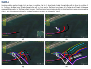
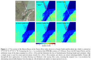
Integrating Google Maps/Earth in an automated oil spill forecast system
.Journal ArticleEstuariesGeospatial AnalysisHazards/RisksNumerical MethodsOil Spills
Hou, X., and B.R. Hodges (2014), “Integrating Google Maps/Earth in an automated oil spill forecast system,” Marine Technology Society Journal, 48(4):79-85, Jul. 2014. http://doi.org/10.4031/MTSJ.48.4.3
Publication year: 2014
Hydrodynamic modeling for river delta salt marshes using lidar topography
.ConferenceEstuariesGeospatial AnalysisNumerical Methods
B.R. Hodges, “Hydrodynamic modeling for river delta salt marshes using lidar topography,” Geophysical Research Abstracts, Vol. 16, EGU2014-15838, presented at the European Geosciences Union General Assembly, Vienna, Austria, April 27-May 2, 2014.
Publication year: 2014
Photographic field reconnaissance of bayous between Green Lake and Mission Lake in the Guadalupe River Estuary
.ReportEstuariesGeospatial Analysis
B.R. Hodges, Photographic field reconnaissance of bayous between Green Lake and Mission Lake in the Guadalupe River Estuary, Center for Research in Water Resources, University of Texas at Austin, CRWR Online Report 12-08, 31 pgs., February 2013.
Publication year: 2013
Hydrodynamic flow modeling of Barton Springs Pool
.Supervised ThesisGeospatial AnalysisLakesNumerical Methods
A.A. Tomasek, Hydrodynamic flow modeling of Barton Springs Pool, M.S. Thesis, Department of Civil, Architectural, and Environmental Engineering, University of Texas at Austin, 87 pgs., Aug. 2013
Publication year: 2013
The effect of grid scale on calibration of two-dimensional river models through the drag coefficient
.Supervised ThesisGeospatial AnalysisNumerical MethodsRivers
R.E. Chisolm, The effect of grid scale on calibration of two-dimensional river models through the drag coefficient, M.S. Thesis, Department of Civil, Architectural, and Environmental Engineering, University of Texas at Austin, 98 pgs., May 2011.
Publication year: 2011
Modeling hydrodynamic fluxes in the Nueces River Delta
.Supervised ThesisEstuariesGeospatial AnalysisNumerical Methods
A.J. Ryan, Modeling hydrodynamic fluxes in the Nueces River Delta, M.S. Thesis, Department of Civil, Architectural, and Environmental Engineering, University of Texas at Austin, 129 pgs., Aug. 2011
Publication year: 2011